Sale of land of 182 hectares, private.
The “Arco Norte” highway divides the land into 2 parts (107 ha on the south side and 65 ha on the north side)
Pending Subdivide and Separate
30 of these are under energy towers with right of way, 10 are from the North Arc.
Land use: Agricultural, the municipality has authorized the change from land use to industrial or mixed
Access routes:
- Autopista Arco Norte divides the land in half (Km 100)
- Junction to the North Arch for Apaxco, 1.5 km away
- Junction to the North Arc in Santa María Ajoloapan 9 km away (10 min Aprox.)
By road Perez de Galeana - Sta Ma, Ajoloapan
- 13 km from Atitalaquiá via Autostrada Arco Norte
- 15 minutes from Tequixquiac via the road that goes directly to the Hacienda -30 minutes from Zumpango
Distance from:
- Petroleum Tower (Peripheral and Reform) 68 Kms (1 hour) - Indios Verdes by Zumpango 66 Kms 1 hour and 30 minutes
- Railroad tracks pass in the town of Apaxco 5 km away (Mexico-Laredo de Tamaulipas)
Price:
$250/m2
Services:
- There is a 350 m deep water well (it belongs to the municipality) Located 100 meters from the town, on land donated by the Treasury.
Water tested under the ground
- The helmet has a 1 1/2 inch water intake
- 4 lines of high-voltage electric power towers cross the terrain. (You have easement of way contracts with CFE for 30 hectares)
- 50 m x 35 m jaguey
- Flat terrain
Features:
a) There is a certificate of irrevocability issued by presidential decree and published in the nation's official gazette dated June 12, 1940.
b) The “Arco Norte” highway divides the land into 2 parts (107 ha on the south side and 65 ha on the north side)
c) The “Arco Norte” highway crosses the terrain for 1.1 km
d) Within the grounds of the Hacienda, there are 2 vehicle bridges that cross the “Arco Norte” highway
e) At the site of the well comes a 23,000 Volt power line, from which low voltage energy can be connected to the land.
f) There are 2 more vehicular bridges on the sides of the Hacienda land that cross the North Arc. They are located on ejido land and reach the town of Pérez de Galeana 800 meters from the farm, one of them entering the land of the Hacienda.
Construction:
Mid 18th century farmhouse (Can be sold separately)
- Retains old original features
- Perimetral wall of 5 meters high
- 10 rooms covered with earthenware, many more without a roof - Church with dome roof
- 110,000 liter water tank
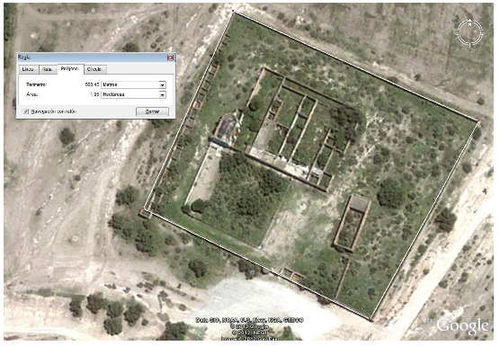
In the image of the Hacienda Land Polygon, you can see the North Arc Highway that crosses in half and shows in the upper left part the location where the junction to Apaxco is projected, in the calculated area of 183 hectares you need to discount 9.5 hectares from the North Arc and other roadsVenta de terreno de 182 hectáreas, particular.
La autopista “Arco Norte” divide el terreno en 2 partes (107 has lado sur y 65 has lado norte)
Pendientes de Subdividir y separar
30 de estas están bajo torres de energía con derecho de paso, 10 son del Arco Norte.
Uso de suelo: Agrícola, se tiene autorizado por el municipio el cambio de uso de suelo a industrial ó mixto
Vías de acceso:
- Autopista Arco Norte divide el terreno a la mitad (Km 100)
- Entronque al Arco Norte para Apaxco a 1.5 Km
- Entronque al Arco Norte en Santa María Ajoloapan a 9 kms (10 min Aprox.)
Por carretera Perez de Galeana - Sta Ma, Ajoloapan
- A 13 kms de Atitalaquia por autopista Arco Norte
- A 15 min de Tequixquiac a través de carretera que llega directo a la Hacienda -A 30 min de Zumpango
Distancia desde:
- Torre de Petróleos (Periférico y Reforma) 68 Kms (1 hora) - Indios Verdes por Zumpango 66Kms 1 hora y 30 minutos
- Vías de ferrocarril pasan en pueblo de Apaxco a 5 Kms (México-Laredo de Tamaulipas)
Precio:
$250 / m2
Servicios:
- Existe un pozo profundo de agua 350 mts (Pertenece al municipio) Ubicado a 100 metros del casco, en terreno donado por la Hacienda.
Agua probada bajo el terreno
- En el casco se cuenta con toma de agua de 1 1/2 pulgadas
- 4 Líneas de torres de energía eléctrica de alta tensión cruzan por el terreno. (Se tiene contratos de servidumbre de paso con CFE por 30 has)
- Jaguey de 50 m x 35 m
- Terreno plano
Caracteristicas:
a) Se cuenta con certificado de inafectabilidad emitido por decreto presidencial y publicado en el diario oficial de la nación con fecha 12 de Junio de 1940.
b) La autopista “Arco Norte” divide el terreno en 2 partes (107has lado sur y 65 has lado norte)
c) La autopista “Arco Norte” cruza el terreno a lo largo de 1.1 kms
d) Dentro de los terrenos de la Hacienda, se cuenta con 2 puentes vehiculares que cruzan la autopista “Arco Norte”
e) En el lugar del pozo llega una línea eléctrica de 23 mil Volts, de este se puede conectar energía de bajo voltaje a los terrenos.
f) Hay 2 puentes vehiculares más a los lados del terreno de la Hacienda que cruzan el Arco Norte. Se ubican en terrenos ejidales y llegan al pueblo de Pérez de Galeana a 800 metros de la hacienda, uno de ellos entra a los terrenos de la Hacienda.
Construcción:
Casco de hacienda de mediados del siglo XVIII (Puede venderse por separado)
- Conserva características originales antiguas
- Muro perimetral de 5 mts altura
- 10 recámaras techadas con loza, muchas más sin techo - Iglesia con techo de cúpula
- Cisterna de agua de 110 mil litros
En la imagen del Polígono del terreno de la Hacienda, se visualiza la autopista del Arco Norte que atraviesa por la mitad y se muestra en la parte superior izquierda la ubicación donde se proyecta el entronque hacia Apaxco, en el área calculada de 183 Has se necesitan descontar 9.5 has del Arco Norte y otros caminos
 Sale of 1882 farm in Apaxco Edo Mex next to the North ArcVenta de hacienda de 182 en Apaxco Edo Mex junto al Arco Norte


 Ver Tour Virtual


